Author Archives: admin

Raspberry Pi Weather Satellite Reception

I followed the instructions on this site https://www.instructables.com/Raspberry-Pi-NOAA-Weather-Satellite-Receiver/ to install all the software required on my new model 4b. There’s an issue with the software used to predict the passes (oddly enough called predict) which requires an additional 3 files to be installed or you’ll never initialise the program with your latitude/longitude details. These are:

wget https://raw.githubusercontent.com/kd2bd/predict/master/default/predict.db
wget https://raw.githubusercontent.com/kd2bd/predict/master/default/predict.tle
wget https://raw.githubusercontent.com/kd2bd/predict/master/default/predict.qth

and put into the same directory as predict itself; namely ~/.predict

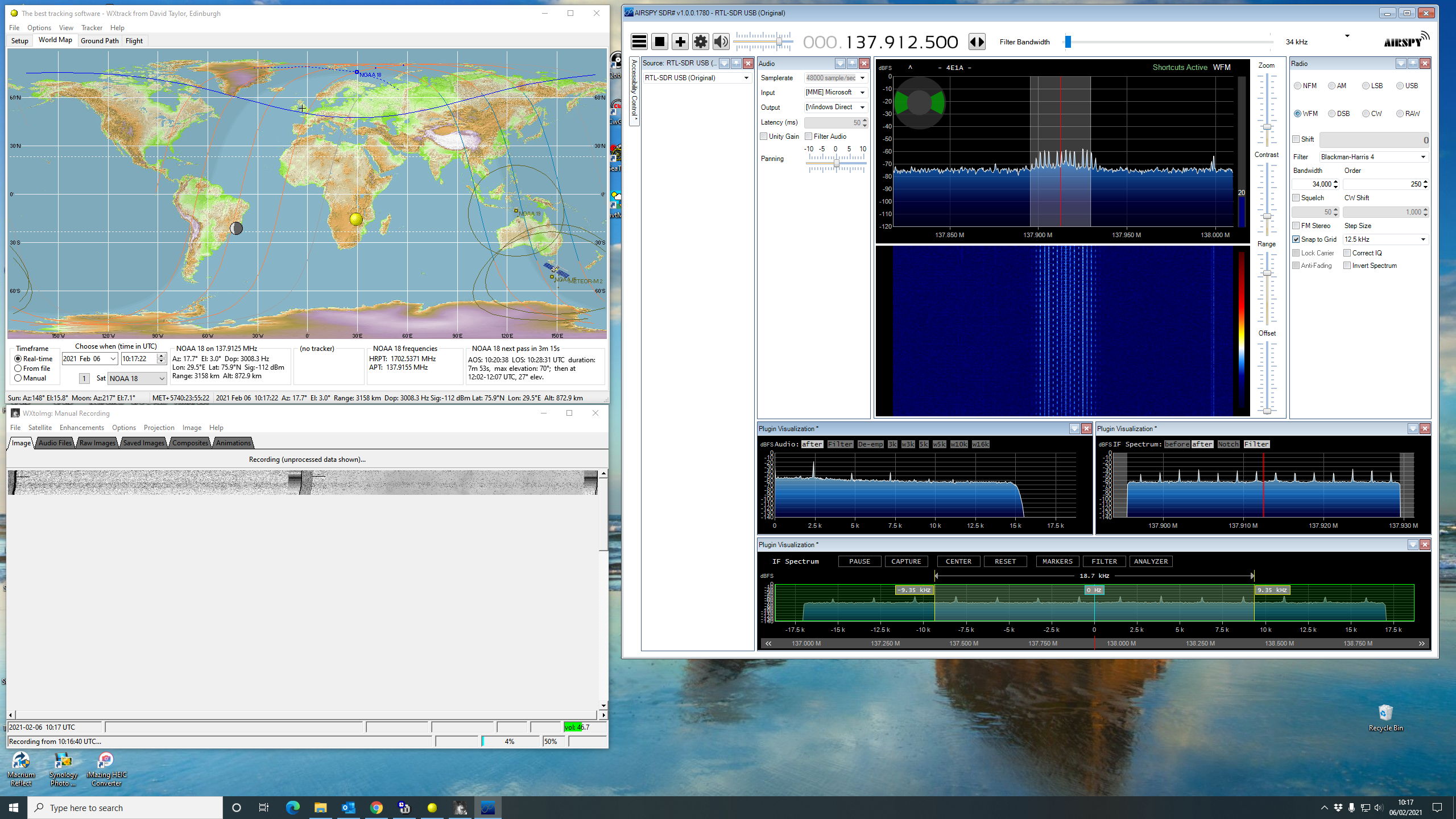
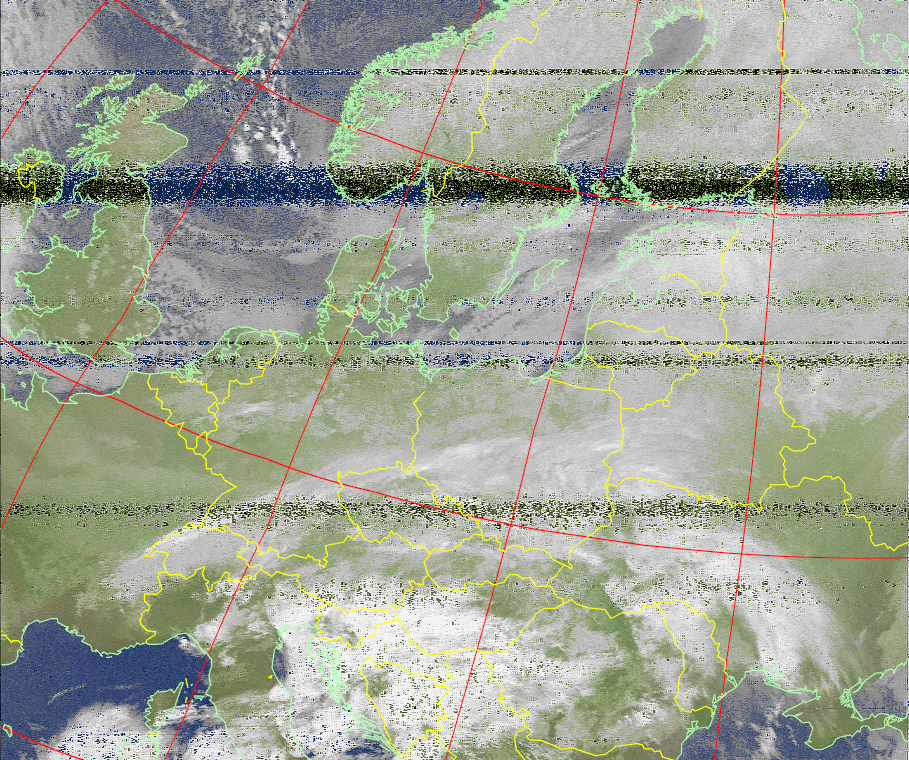
My Nooelec/Sawbird+NOAA combination was plugged into one of the Pi’s USB3 sockets, antenna connected (still Diamond V2000) and the wait was on for the passes to arrive. The first two passes scheduled were low northbound with maximum elevation of only 29 degrees. You can see the results below:

NOAA 19 northbound 16.32z 10-Feb-2021 with HVCT enhancement
NOAA 15 northbound 17.26z 10-Feb-2021 with MCIR with precipitation enhancement

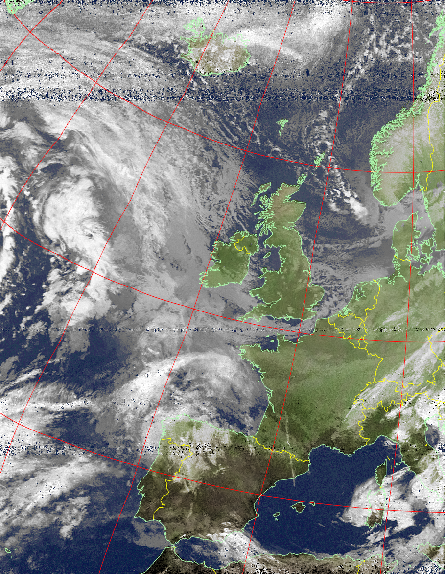
The next two passes were higher with maximum elevations of 63 degrees.

NOAA 19 northbound 18.11z 10-Feb-2021 with MCIR with precipitation enhancement
NOAA 15 northbound 19.05z 10-Feb-2021 with MCIR with precipitation enhancement

So – excellent results! That really concludes the indoor experiments. Sure I may add some code to upload automatically images to this blog – maybe a specific page. And of course add a 7″ screen to the Pi to display the images. I need to get that turnstile antenna assembled and installed though!

In conclusion it is a bit of a faf to receive weather satellite images on the Pi. There is far more work involved than on a PC. And that is even with the three scripts used already being written for you to use or modify as you wish (incidentally some of the comments on the web site I linked to earlier are pretty good, and you learn more about how to fine-tune the set-up). However the convenience of having the Pi tucked away somewhere on the floor, behind the desk, with the small Nooelec devices attached with the antenna lead-in, are large. You don’t have to tie your PC up when it could be doing something else – like recording the MF band overnight for example!

N.B.

Couple of things I’m wondering about and need further investigation. Firstly the Pi images seem to be “cleaned-up” when compared with the same images obtained by loading the wav file into the PC version of wxtoimg. Secondly the images I’ve labeled as MCIR with precipitation enhancement don’t appear to be that enhancement (there is no colour). Watch this space…

Nooelec SmarTee with Sawbird+ NOAA

So the final test for pc reception was using the Nooelec SmarTee V2 with the Nooelec Sawbird+ NOAA 137 MHz pre-amp and filter. The results are shown in the two images below. Pretty darn good I think you’ll agree!

The filter appears to clean-up the image once you have a decent signal. Superb performance for the Smartee combination.

NOAA 19 northbound 16.56z 8 Feb 2021 MCIR with Precipitation enhancement
NOAA 18 northbound 18.16z 8 Feb 2021 MCIR with Precipitation enhancement

That concludes the PC tests. Next indoor steps are to get the Raspberry Pi 4b decoding passes with the SmarTee/Sawbird combo and outdoors to get the turnstile antenna up.

Weather Satellite Reception with Nooelec Smart V4 Dongle

Couple of images from yesterday and this morning using the Nooelec Smart V4 sdr-rtl usb stick. The first image I had the gain set at 34 db before increasing it about half way through the pass to 44 db. Made a large difference to the quality of reception. Seem like the new generation of rtl-sdr sticks are much better with high gain settings. The older ones would just overload badly.

Second pass is a southbound one for a change. One more test to go with a Nooelec SmartTee (built-in bias-t) with Sawbird 137 MHz filter. However I’d be amazed if I got better results as I’m pretty happy with what I’ve managed so far.

NOAA 19 northbound at 17.30z on 5 Feb 2021. MCIR with Precipitation enhancement.
NOAA 18 southbound at 10.18z 6 Feb 2021. MCIR with Precipitation enhancement.

To compare my results with the “professionals” check out this site http://rssconsultancy.co.uk/wxtoimg/

Finally here is a screen grab of my set-up taken at the beginning of the NOAA 18 pass today.

WXTrack. wxtoimg and SDR# all working in perfect harmony…

More Weather Satellite Images

Same kit as yesterday and the same two passes shown below – both with MCIR with Precipitation enhancement.

NOAA 19 northbound at 17.41z MCIR with Precipitation enhancement
NOAA 15 northbound at 18.16z MCIR with Precipitation enhancement

Weather Satellites – Airspy Discovery HF+

So continuing my experiments I plugged in my Airspy Discovery HF+, checked all was working ok with SDR# V1780 and configured VAC so I could direct audio output from SDR# into wxtoimg. If anyone is interested the VAC settings which worked for me are shown in the image below.

VAC settings for weather satellite reception

I then fired up wxtoimg and set the Recording input to be VAC Line 1. You can then go into Windows 10 properties for VAC Line 1 (Recording) and click Listen to This. So you can hear the satellite audio as it is being piped into wxtoimg. I set the SDR# mode to be WFM with a 34k bandwidth. The results were the two images below. I’m pretty pleased with the pictures. Next step is to see how a Nooelec Smart SDR and a Nooelec Smartee (with built-in Bias-T) to power a Sawbird NOAA 137 MHz filter and pre-amp work. And if it ever stops raining for a day or two to get the turnstile antenna up.

NOAA 19 northbound at 17.53z pristine image.

NOAA 15 northbound at 18.41z MCIR enhancement image.